Colombia
COLOMBIA BORDERLAND SECURITY PROPOSAL: Comparative Analysis of Cauca-Nariño and Urabá-Chocó
Executive Summary
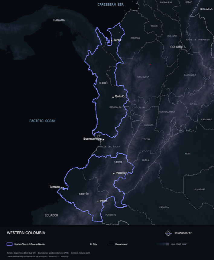
Colombia’s western pacific coast region is a mosaic of mountain hold outs, river smuggling routes, and port distribution chains all puzzled together by a competing network of rival armed actors. The historically underdeveloped and isolated regions of Cauca-Nariño and Urabá-Chocó form connected Pacific conflict systems, but key differences between them require distinct security approaches for each.
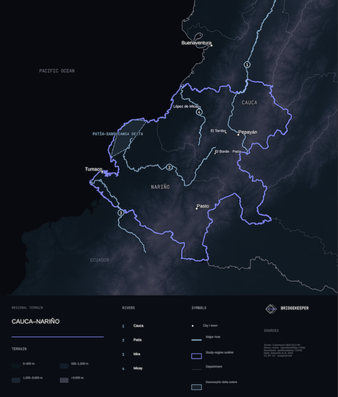
Cauca-Nariño spans Andean cities, mountain corridors, the Micay basin, Pacific lowlands, and the shared border with Ecuador. The Revolutionary Armed Forces of Colombia (FARC) dissidents and the National Liberation Army (ELN) operate here through shifting local fronts and alliances contesting coca processing, illegal mining, and coastal port facilities.
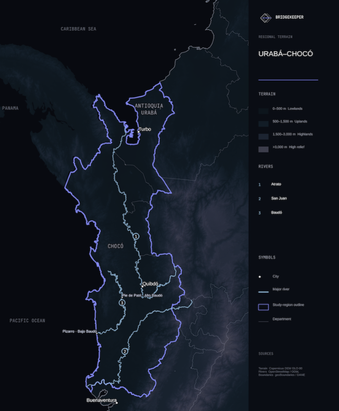
Urabá-Chocó joins Antioquia's commercial banana and port belt with Chocó's dispersed river communities and collective ethnic territories where the Ejército Gaitanista de Colombia (EGC), commonly known as Clan del Golfo, holds the dominant share of power. The EGC exercises nearly uncontested armed control, through river and road closures, over much of the river traffic at the heart of the region's transport economy. Any security solution in this isolated region must consider the terrain and geographic nexus of international distribution.
Regional Comparison
The full Cauca-Nariño frame includes all 42 municipalities of Cauca and all 64 municipalities of Nariño. DANE projects 3,335,064 residents in 2026, including 1,996,438 people in populated centers and dispersed rural areas. The full Urabá-Chocó frame includes all of Chocó and Antioquia's eleven official Urabá municipalities. DANE projects 1,121,717 residents, including 547,293 in populated centers and dispersed rural areas.
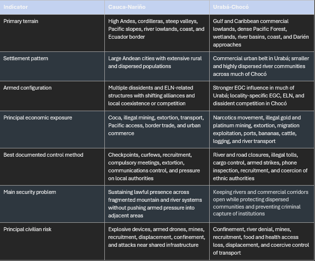
Cauca-Nariño is a regional mix of highland cities, Indigenous territories, Afro-Colombian collective territories, campesino zones, coca-producing areas, mining districts, mountain roads, river corridors, Pacific ports, and an international land border. Instead of one armed order, Defensoría and OCHA reporting show separate conflict systems in northern Cauca, the Nariño mountains, the Pacific coast, and the Ecuador border. Violent intimidation is commonly used to control civilian populations or how they share information. Even during periods of relative peace local inhabitants understand very well the dangers that are ever present for any who disobey. FARC and ELN dissidents operate through separate local networks but share common methods for control: checkpoints, curfews, compulsory meetings, extortion, kidnapping, and selective killing. In parts of Patía and El Tambo, Cauca, the Carlos Patiño Front demands payments from households and cattle owners, imposing compulsory road work on residents who do not pay. The group also attempted to impose identification requirements; In El Peñol and El Tambo, Nariño, armed actors issued instructions through WhatsApp and printed pamphlets. Mines, drone-delivered explosives, and infrastructure attacks further restrict movement while also lending credibility to threats against community leaders or residents to discourage reporting abuses to legitimate government authority. These methods allow armed groups to enforce their demands without occupying every settlement. State security forces must focus on disrupting coercive networks, maintaining civilian access, and protecting local institutions.
Urabá-Chocó has a different internal split. The Antioquia component contains the banana axis, Gulf ports, road connections, commercial centers, as well as migration routes. Chocó depends far more heavily on the Atrato, San Juan, Baudó, and smaller river systems for economic transport of goods. The available record indicates stronger EGC influence in much of Urabá, while locality-specific EGC, ELN, and FARC dissident competition persists in Chocó. Armed territories often overlap and change but river closures, curfews, illegal tolls, cargo seizure, phone inspection, recruitment pressure, and interference with ethnic authorities provide better evidence of armed governance than sharply defined territorial-control maps. It’s in these details that government intelligence apparatus must search for defining the battle space and identifying valuable targets.
The humanitarian record in this coastal region also differs. OCHA reported 29 mass displacement events affecting about 6,122 people in Cauca during 2025, along with 19 confinement events affecting 33,227 people and 59 mobility-restriction events affecting at least 452,836. Nariño recorded 18 mass displacement events affecting 7,175 people. These events display a significant impact on the local populace’s ability to sustain themselves consistently. If civilian mobility is erratic and unpredictable, development projects will be untenable and government legitimacy will be called into question.
In Chocó, OCHA reported at least 2,550 people still confined and 178 displaced in Bajo Baudó as of 4 June 2026. About 12,605 people across Alto and Bajo Baudó faced mobility and access restrictions. The Urabá-Darién briefing recorded 3,062 individual displacement victims in its wider reporting frame during 2025, plus smaller reported totals for confinement and access restrictions. That frame includes Chocó municipalities outside Antioquia's eleven-municipality Urabá subset.
Applying Peru's Shining Path Lessons in the Mountains: Cauca and Nariño
Peru did not defeat the Shining Path through one campaign or a single tactic. The decisive shift arrived when improved state relations with local communities fostered rural resistance, combined with selective operations as well as skillful law enforcement intelligence collection. Peru's Truth and Reconciliation Commission found that by the late 1980s and early 1990s the state had strengthened intelligence work, used more selective military actions, and incorporated organized rural resistance into its strategy. The same report concluded that the expansion of peasant patrols and self-defense committees blocked Shining Path advances in much of the countryside and forced the organization toward cities and remote forest areas.
The police intelligence model matters most for Cauca and Nariño. Peru's Special Intelligence Group, GEIN, rejected the demand for quick public results. It followed identified militants patiently, mapped their relationships, and worked inward toward the leadership. That approach produced a series of arrests between 1990 and 1992 and culminated in the capture of Abimael Guzmán and senior Shining Path leaders on 12 September 1992. The Peruvian commission described the operation as the result of meticulous DINCOTE intelligence and GEIN's decision to pursue the leadership network rather than stage small arrests for television.
The Colombian application should be narrow. Police and judicial intelligence should lead the effort to identify command relationships, financial facilitators, recruiters, extortion systems, and links between rural fronts and urban support. Military units can secure access and protect investigators, but large area sweeps are a poor substitute for network analysis. Front names and national umbrella labels should not drive arrests or strikes without current, case-level corroboration. The actor picture in Cauca and Nariño is too fluid for that.
Mountain presence of security forces should protect population and institutions rather than occupy empty terrain. Security forces should maintain reliable access around municipal services, schools, health posts, justice channels, and major civilian transport corridors, then extend presence through mobile patrols and temporary operating locations. The test is whether residents can travel, report crimes, attend school, move produce, and receive medical care after the patrol leaves. Body counts and temporary entry into a village are weak measures of control.
Peru's rural defense experience requires tighter limits in Colombia. The rondas campesinas and self-defense committees helped deny Shining Path access to communities and information. A 1992 United States country study reported that about 1,500 rondas in the Mantaro Valley had imposed major setbacks on the insurgency. It also described the rondas as the Fujimori government's most successful counterinsurgency measure at that stage. Yet the Truth and Reconciliation Commission also found serious human rights violations by some self-defense committees and state forces. The lesson is not to arm new local militias. Colombia already has legitimate Indigenous guards, community councils, cabildos, and other civilian protection institutions. The state should protect their autonomy, fund civilian early warning and communications, and provide confidential reporting routes. It should not direct them to identify targets, detain suspects, or serve as compulsory informants.
The same distinction applies to influence activity. State messaging should report verified service restoration, lawful arrests, reopening of routes, protection of schools, and demobilization opportunities. It should avoid exaggerated claims of control. Armed groups exploit failed promises and civilian harm more effectively than any government media campaign can offset. Credibility comes from repeatable conduct: disciplined checkpoints, compensation for damage, accessible complaint mechanisms, and visible investigation of abuse.
River Control in Chocó, Urabá, and the Pacific lowlands
River control is the center of gravity for much of Chocó and the Pacific lowlands of Cauca and Nariño. OCHA and Defensoría reporting shows that armed groups can stop fishing, farming, school transport, medical evacuation, markets, and humanitarian relief by controlling a small number of river access points or imposing travel hours. This is functional control that does not require permanent occupation of every community.
The riverine concept from the Arauca-Catatumbo assessment should be used in Chocó and the Pacific lowlands with an emphasis on three things. First, small shallow-draft craft should conduct most patrol and inspection work because tributaries, debris, changing water levels, and narrow channels limit larger vessels. Second, larger patrol or support vessels should act mainly as logistics, maintenance, communications, medical, and command platforms at defended hubs. They should not force small craft to remain within immediate visual range. Third, patrol timing and routes should vary. Static checkpoints alone allow armed groups to shift traffic around predictable positions.
The purpose of patrols is to preserve lawful civilian navigation by making it costly for armed groups to collect tolls, seize cargo, recruit, or transport weapons and narcotics. To distinguish legitimate state authority from armed-group criminality, boarding and inspection must use published rules, accountable records, and clear procedures for civilians carrying fuel, food, medicine, fishing gear, or other commercial cargo. Poorly disciplined interdiction by state forces can reproduce the armed groups' own system of arbitrary tolls and permissions. Such misconduct would give armed groups a political victory by making state presence appear equally arbitrary.
River control also needs an institutional follow-on package: mobile health teams, victim registration, school transport, market access, communications repair, and humanitarian liaison should move behind protected access. Larger support vessels and shore hubs can help sustain logistics and transportation functions where roads are absent. Security presence without services may disrupt an armed route for a few days, but it does not replace the order imposed by the armed group.
Urabá requires a different approach than one designed for Chocó. Riverine and coastal patrols remain relevant around Gulf, Atrato, and border-linked systems, but the banana axis and port economy demand financial investigation, port integrity, contracting oversight, anti-extortion work, and protection of migrant routes. The EGC's strength in Urabá is tied to its penetration and coercion of licit institutions and commerce as well as its access to remote terrain. A purely riverine campaign would leave that structure intact.
Coordinated Regional Approach
The two composites should be synchronized at the strategic level but not merged into one campaign map. Cauca-Nariño requires a mountain and network approach with separate plans for northern Cauca, Micay and Pacific Cauca, the Macizo and Patía systems, the Nariño cordillera, the Pacific coast, Tumaco, and the Ecuador border. Urabá-Chocó requires plans for the commercial Urabá belt, Gulf and Darién approaches, Atrato, Baudó, San Juan, and the southern Pacific. Each subregional plan needs its own actor assessment, civilian-risk baseline, access measures, and institutional commitments.
Security action in one corridor can shift armed personnel and civilian risk into another. Defensoría reporting from Patía and El Tambo noted that pressure in the Micay area contributed to armed movement into adjoining zones. That is a warning against declaring success after clearing one locality. Commanders and civilian authorities should track displacement, new checkpoints, extortion demands, recruitment reports, school closure, medical access, and attacks on leaders in adjacent municipalities before judging an operation effective.
Intelligence collection must remain compartmented from community governance. Security institutions do need local knowledge, but compulsory cooperation exposes civilians to retaliation. Separate police and judicial collection teams should develop cases through surveillance, financial records, communications evidence, captured material, and voluntary protected sources. Community authorities should retain their public role in mediation, service coordination, early warning, and civilian protection.
The state should use common measures across both regions:
-
Hours and days of verified civilian river and road access.
-
Functioning schools, health posts, markets, justice offices, and victim registration routes.
-
Time required for medical evacuation and humanitarian delivery.
-
Recorded extortion, illegal toll, checkpoint, confinement, recruitment, and displacement events by municipality and source system.
-
Threats or attacks against ethnic authorities, community leaders, teachers, health workers, and humanitarian personnel.
-
Judicially supported disruption of leadership, finance, recruitment, and logistics networks.
-
Complaints and investigations involving state personnel, with public disposition where protection permits.
These measures are harder to manipulate than claims of territorial recovery. They also show whether security activity produces durable civilian benefits.
Strategic Assessment
Cauca-Nariño and Urabá-Chocó share armed group competition over transport corridors, illicit economies, and local authority; however, their terrain and political economies require different operational methods. Cauca and Nariño need intelligence-led pressure on fragmented networks, persistent mountain access, and protection of civilian institutions. Chocó and the Pacific lowlands need mobile shallow-draft patrols supported by larger logistics vessels, with rapid restoration of transport and services. Urabá needs river and coastal control combined with financial, port, contracting, and anti-extortion investigations.
Peru's experience against the Shining Path supports three conclusions. Patient intelligence collection is more effective than indiscriminate sweeps. Local resistance can isolate an insurgency but forced or poorly controlled civilian defense can create abuse and lasting political damage. Tactical gains become durable when legitimate local institutions survive, and the state continues to provide justice, movement, and services.
Public reporting demonstrates multi-ton illicit shipments across the study regions, but does not establish a consistent regional breakdown by transport mode. Authorities attributed approximately five tons of monthly cocaine movement to one illicit aviation operation in Nariño and up to three tons of monthly export capacity to one Urabá–Chocó-linked network. Separate interceptions document multi-ton port and maritime cocaine shipments, ton-scale road movements of marijuana, and substantial river borne illegal timber cargo. If a single route for illegal cargo is shutdown, the armed groups can pivot to a different one. The least adaptable cargo is timber, being too heavy to fly out of the country. The focus of government action in these areas needs to be on providing consistent security to the local populace.
The people in these regions are the center of gravity. By providing secure travel, local government legitimacy, and consistent commercial river access the Colombian government can reduce the permissive occupation of these regions by illegal armed groups. It is essential that these groups do not enjoy unfettered access to the key terrain (rivers and ports) so that their control of the population is not just limited but degraded. While ports are important, their impact on securing the population is indirect; the significance of their inclusion in a coordinated state effort is to strangle the funding that armed groups receive from illegal exports at these facilities.
The Colombian objective should therefore be the precise application of these measures: State projection of power on major river transits and tributaries, deny armed groups the ability to regulate civilian activities, while enhancing lawful community leader legitimacy. State operations that seize terrain but leave rivers restricted, or leaders exposed to reprisal, and justice institutions absent have not secured the region.

May-akda
Eli
editor
BridgeKeeper